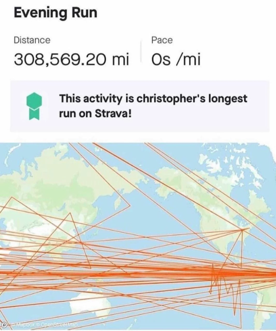
This is more about the weird pathing and not the distance, but here’s what it looks like when I have a bouldering session. Apparently I spend a lot of time outside and pass through walls.
Kind of goes haywire when cell signal drops out. Might be in a brick or concrete building? Mine was in an area of the mountains where using the phone was doomed. I’ve been using a garmin since and it never does this. In a pinch, I used my phone on a hike the other day, and next to big boulder, it did the same thing you’re showing, sent an impossibly straight line up a mountain.
Oh, so it becomes alt text? That’s brilliant. It just disappeared but I didn’t realize what happened. Or I’m misunderstanding (not seeing the text). Nope, I see it if I click on show source.

Strava is the best for this.
(I still don’t understand how to load images here)This is more about the weird pathing and not the distance, but here’s what it looks like when I have a bouldering session. Apparently I spend a lot of time outside and pass through walls.
Kind of goes haywire when cell signal drops out. Might be in a brick or concrete building? Mine was in an area of the mountains where using the phone was doomed. I’ve been using a garmin since and it never does this. In a pinch, I used my phone on a hike the other day, and next to big boulder, it did the same thing you’re showing, sent an impossibly straight line up a mountain.
Get it with a Garmin that uses the two satellite types and worse with a Suntu I use for extreme outdoors. Must be a tin roof or something.
Bouldering inside a faraday cage.
Just standard GPS drift tbh
22m elevation during a boulder session? Pick up the slack jeez.
its
so,
Thanks. Edited it. Works!
Also you can add a text description of the image between the brackets if you’d like. It helps blind people.
Oh, so it becomes alt text? That’s brilliant. It just disappeared but I didn’t realize what happened. Or I’m misunderstanding
(not seeing the text). Nope, I see it if I click on show source.Also, some apps like Voyager will show the alt text as a caption when you open the image.
That’s what I was expecting. Have to check that out. Thanks.